How to Predict The Weather
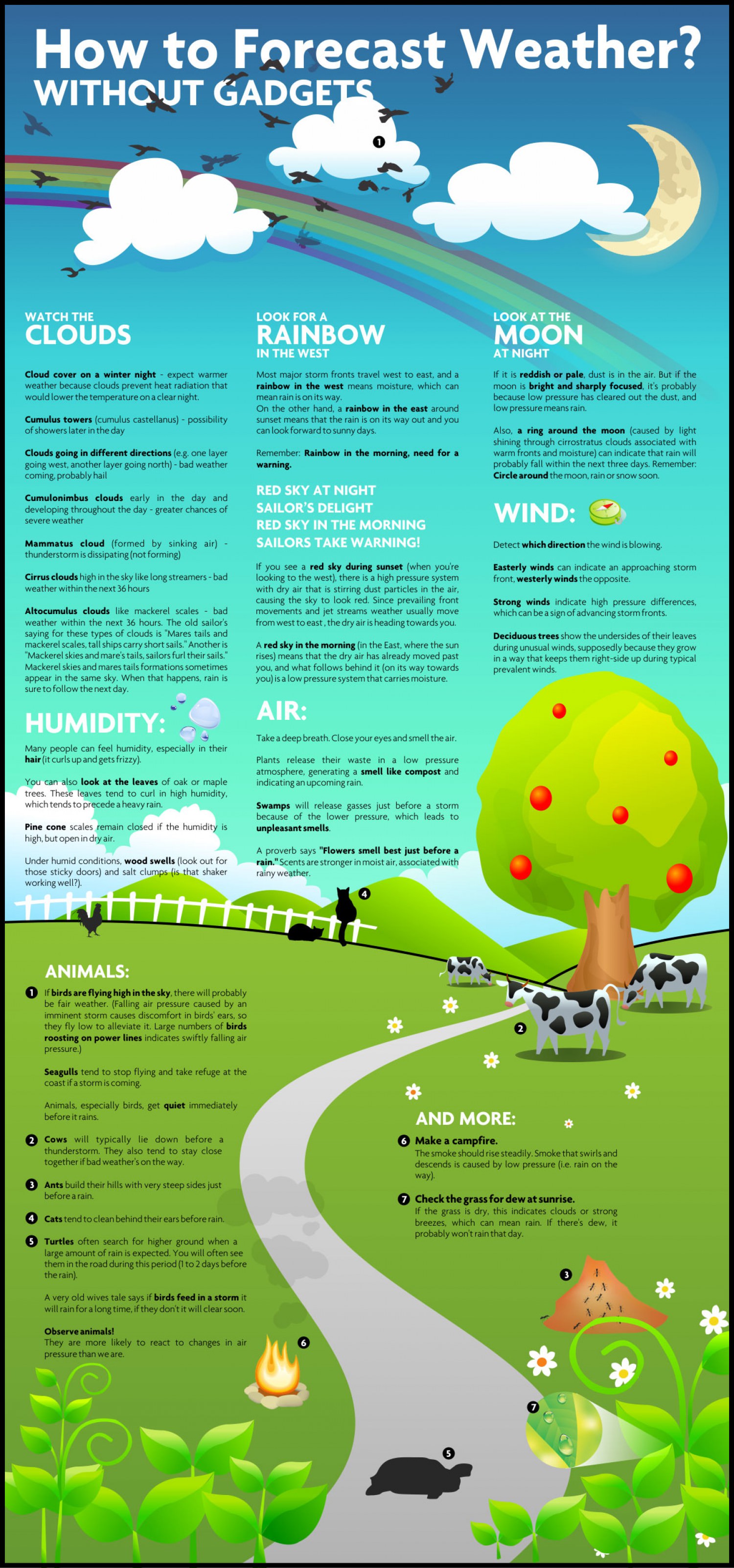
Nowadays, people rely heavily on the
weatherman to know what’s coming, but people used to predict the weather
quite accurately even before technology could. This simple infographic
will teach you the signs to look for that will allow you to make your
own, highly accurate weather forecasts.
Click on the image to see a full-sized version
|
|
| Source |

This blog contains lots of articles and world news. Its aim is to be a source of knowledge for people to read and think, and thus make an intuitive decision on how to lead their lives fruitfully in every-day livings.Under the concept of Today-Readers are Tomorrow Leaders.' The world will be better because we begin to change for the best.
วันพฤหัสบดีที่ 8 มกราคม พ.ศ. 2558


Seven of the world’s riskiest roads

HIDE CAPTION
(Peter Walton Photography/Getty)


As Robert Frost knew well, the road less travelled is often the more interesting choice – at least when it comes to talking about one’s travels.
In order to find some routes both less-trodden and worth bragging
about, we asked the users at question-and-answer site Quora “What are the world’s most interesting roads?”
While some readers described routes that traverse one of the
world’s coldest regions, or tunnels that only measure 4m wide, other
respondents took our question to its limit, recommending roads that were
not only interesting, but dangerous as well. In those cases, the roads
are less frequented for a reason: read on for terrifying drop-offs,
unpredictable mudslides and a complete lack of concrete paving.National Road 5, MadagascarFor National Road 5, which runs north-south between the towns of Maroantsetra (pictured here) and Soanierana-Ivongo on the African country’s east coast, “you need to hire both a driver and a mechanic,” said Anders Alm, chief technology officer for WAU, a travel agency that provides regular trips to the area. If you’re “bored of concrete”, he added, this drive – which he called “the worst road in the world” – would be one way to change it up.
With sections of sand, solid rock and even worn-down bridges that drivers must inspect before crossing, the 200km road takes nearly 24 hours to drive. It turns especially treacherous during the rainy season (December to March), when the lack of asphalt or concrete paving leads the road to become impassable in many spots.
The upside? Most of National Road 5 runs along the white sand coastline, providing spectacular views of palm tree forests and the Indian Ocean.
- Madagascar's National Road 5. (Olivier Cirendini/Getty)

Rohtang Pass, IndiaRohtang means literally, “pile of corpses” – a name that stems from the deadly mudslides that often cover the 4,000m-high road in the eastern Himalayas. Not to mention the area’s generally unpredictable weather, including snowstorms and sudden avalanches.
“Each season, road crews use GPS to find the road and dig it out again,” said Witold Chrab, a Washington DC-based engineer who drove a motorcycle across the pass in 2011. Once cleared, the pass generally remains open from May to November – though snow can make it impassable at any time; in 2010 it left 300 tourists stranded. An 8km tunnel is being constructed beneath the pass to provide a safer option, but the original route, which connects the Kulu, Lahual and Spiti valleys in northernmost India, lures visitors with views of rugged mountain ranges, sprawling valleys and even a mountain goat or two.
- India's Rohtang Pass. (Praphat Rattanayanon/Getty)

Transfăgărășan Road, RomaniaWhile well-known in the world of auto enthusiasts – its 90km of hairpin turns and dramatic descents earned it the title of “best road in the world” by the BBC Top Gear crew – fewer casual drivers know of Romania’s second-highest road. Built as a military route in case of an invasion in the 1970s, the road connects the two tallest mountains in the Southern Carpathians, Moldoveanu and Negoiu, and ascends a total of 2,034m in altitude.
“If you like changing gears every three or four seconds, you know it's fun,” said Romanian native Razvan Baba. Even more fun? Nobody tends to be around to enforce the 40km/h speed limit, Baba said – though the hairpins make it tough to go much faster.
- Romania's Transfăgărășan Road. (Hutch Axilrod/Getty)

Eyre Highway, AustraliaCarl Logan, a police officer from Perth, warned readers that this 684-mile stretch in southern Australia might seem “plain and boring” at first glance, but actually holds plenty of adventure – particularly with its animals. “You might see kangaroos, emus and sometimes even camels,” he said. The wildlife also makes the route riskier, as a wandering animal can seriously damage an oncoming car.
The most dangerous time to take on the highway – which runs between the towns of Norseman and Ceduna – is dawn or dusk, when most wildlife attempts to cross the road. But those who do drive at nightfall will be rewarded. “Because there is no civilisation, the night stars will be the brightest you've ever seen,” Logan said.
Prithvi Highway, NepalRunning 174km from Kathmandu to Pokhara past sights such as Annapurna, the 10th-tallest peak in the world, and its conservation area (pictured here), this road’s dramatic views come at a potentially high cost. “In addition to beautiful views of the Himalayas, you will see vehicles that have ended up in the river chasms,” said Janet M Foley, a Las Vegas resident who drove the route. Prithvi Highway also passes some of the country’s most important religious sites, including the sacred Manakamana Temple.
Foley said the “joy ride” was well worth it one way – but decided to catch a plane back to Kathmandu rather than pressing her luck twice.
- Annapurna's conservation area. (Jochen Schlenker/Getty)

Kolyma Highway, SiberiaLocals know the Kolyma Highway, or M56, as “Trassa” – simply “The Route” – because in this desolate, frozen region of eastern Siberia, it is the only main road.
Another nickname for the highway, “the road of bones”, speaks to its tragic history: it was built by the hundreds of thousands of political prisoners who were exiled to the region’s gulags under the Stalin regime from the 1930s to the 1950s. Thousands were shot for not working hard enough, while others died from the gulags’ brutal conditions. The cold was another killer: with temperatures recorded as low as some -70C, the Kolyma is located in the world’s coldest inhabited area. Many of the dead simply were buried beneath the road’s foundations.
After the road fell into disrepair for decades, actor Ewan McGregor and TV presenter Charlie Boorman took a motorcycle journey on it in 2004 for the TV show Long Way Round. Kolyma Highway was designated a federal road in 2008 and began to attract a band of particularly adventurous – and cold-loving – motorcycle enthusiasts. Today, the 2,031km route is still known as the “world’s coldest road”, said world traveller Filipp Peresadilo, with snow falling even in July and August. It also remains one of the most desolate, with few travellers knowing of the world’s most frozen road – or its tragic history.
- Siberia's Kolyma Highway. (Amos Chapple/Getty)

Guoliang Tunnel, ChinaFor decades, the tiny cliff top village of Guoliang, located in the Taihang Mountains of eastern China, was reachable only by climbing the mountain on foot. After the government refused to build a road, effectively leaving the village to become a ghost town, the locals decided to take matters into their own hands. From 1972 to 1977, they used explosives and shovels to dig their own 1.2km tunnel; some lost their lives in the process.
Dangerous to build, the route is also dangerous to drive. Perched on the top of a cliff and measuring a narrow 4m wide, the Guoliang Tunnel is particularly treacherous after rains, when it can become very slippery. Thirty “windows” in the stone face, meanwhile, give spine-tingling glimpses of the valley far below. “China is the place to visit if you’re looking for extreme roads,” said Quora contributor Lewis Shaw. “Just don’t look down!”
- China's Guoliang Tunnel. (Zhen Miao/Getty)

In Iraq's war against extremists, a quiet sectarian purge


RAWASHID, Iraq (AP) —
Sunni residents of this tiny village north of Baghdad are all gone.
Their homes now have Shiite graffiti scrawled on the walls. Shiite
banners, many emblazoned with images of revered saints, are hoisted on
the roofs.
The only
people here now are Shiite fighters, who nearly two weeks ago helped
Iraqi forces wrest the town from the Islamic State group. Outside one of
the homes the fighters have occupied, their leader sat with his men on a
recent day, warming themselves by a fire where tea brewed.
He made it clear: They have no intention of allowing the Sunnis back, accusing them of supporting the extremists.
"If
we allow the residents of this village to return to their homes, they
will do it all over again to us," said Adnan Hassan, 59. The militants
used the village to fire mortars at the nearby, mainly Shiite city of
Balad — and they still hold villages only a few miles away.
"These
are our lands. They were taken away from us centuries ago," he told The
Associated Press, pointing to the orchards and lush farmlands
surrounding the village's relatively affluent homes.Hassan's claim of Shiite ownership of the lands is tenuous at best. But his comments expose a grim side of Iraq's fight against the Sunni militants of the Islamic State group: The war is being used by Shiite militiamen to change the demographics of Sunni areas, in an attempt to solidify Shiite control. The practice appears mostly focused on Sunni areas astride roads leading to important Shiite shrines to the north and south of the capital, Baghdad.

The apparent sectarian
cleansing plants the seeds of future conflict — or even an outright
civil war that could eventually break up the nation along sectarian and
ethnic lines, a fate that a growing number of Iraqis, particularly
Sunnis, see as the solution to the nation's bloody turmoil.
Tens
of thousands of Iraq's Sunnis fled their home regions over the past year
to escape the brutal rule of the Islamic State group. The militants
swept over much of the north and west of Iraq, overrunning
Sunni-majority regions all the way down to the doorstep of Baghdad.
Shiite-led
security forces and militias made up of Shiite volunteers have since
driven the militants out of some of those areas. But the Sunni residents
have mostly been prevented from returning, on the grounds that the
regions are not yet safe. In many cases, they have been unable to return
because their homes have been destroyed in the fighting or blown up by
militiamen.
Sunnis who stayed
put and endured Islamic State governance face a worse predicament when
Shiite forces recapture their areas. They are accused of helping the
militants, often their homes are blown up, men jailed or entire families
banished, with their properties given to Shiites.
The militiamen
appear to be the ones enforcing the demographic change, unsettling the
Shiite-led government. The danger is real enough that Shiite Prime
Minister Haider al-Abadi has spoken forcefully about the need for
national unity. Addressing graduating army cadets Tuesday, he called for
residents of liberated areas to be allowed to return to their homes, so
that their suffering ends. In an unusually bold gesture of
reconciliation, he visited the capital's two landmark Sunni and Shiite
shrines on Friday.
Iraq's top Shiite cleric,
the Iranian-born Grand Ayatollah Ali al-Sistani, condemned the excesses
of militiamen in a fatwa, or an edict, issued last weekend, specifically
citing the theft of property in areas liberated from the Islamic State
group.
"What we are dealing
with here is a real attempt at demographic change, coupled with blatant
abuses," Sunni politician Hamed al-Mutlaq told The Associated Press. "It
is now extremely difficult for the Sunnis to return to their homes" —
not because their homes have been destroyed, he added, "it is genuine
fear that is stopping them."
The
sectarian shift comes on top of one that occurred in the wave of
vicious sectarian fighting sparked in 2006, when Sunni militants blew up
the Shiite shrine of Imam al-Askari in the city of Samarra, north of
Baghdad. That conflict became a virtual civil war, and it purged Baghdad
of most mixed neighborhoods, leaving it sharply divided between Shiite
and Sunni districts.
In
Diyala province, northeast of the capital, Islamic State militants have
almost completely been driven out, but Sunni Arab families have not been
allowed back, said Raad al-Dahlaki, a Sunni lawmaker from the province.
The province is a major route for Iranian pilgrims traveling overland
to shrines in Iraq.
"They say
they will only allow 'loyal' residents to go back. This is an excuse to
change the demographics of the province," al-Dahlaki said.

Al-Mutlaq and other Sunni
politicians said the area around Balad, about 65 kilometers (40 miles)
north of Baghdad, is also targeted to keep out Sunnis.
Balad
is home to the shrine of one of the imams revered by Shiites and sits
on the main highway from Baghdad to Samarra. While many of the larger
towns in the area have Shiite majorities, the surrounding countryside
along the Tigris River is dotted with Sunni towns and villages like
Rawashid. Over the past weeks, Iraqi forces backed by Shiite volunteer
fighters swept across the area, pushing back the extremists and trying
to clear a corridor to Samarra.
Iraqi federal police and Shiite
volunteers battled for five hours late last month to retake Rawashid. On
Saturday, when AP journalists visited, the police were gone, and the
volunteers led by Hassan were settled in, taking over several houses.
Other houses were blackened, possibly by fire or shelling, or flattened
by airstrikes.It is not clear whether the village's estimated 1,000 residents fled when the Islamic State militants took over in the summer or when the village was retaken. Either way, none were in sight Saturday.
Laith Ahmed, an
official with the "Popular Mobilization Authority" — the state agency
overseeing the volunteers — painted the entire village population as
Islamic State supporters.
"They own some of the most fertile farms in Iraq, so it's
beyond me why they chose to take the side of the armed militants," he
said.
Anti-Sunni bias is just as pronounced in Balad. There, Shiite residents successfully kept the Islamic State militants at bay during a weeks-long siege in June and July. The city's small Sunni population fled.
"By God, I will never allow the Sunnis to come back to Balad," said Mudhafar Abdul-Reddah, a Shiite in his 50s. "They were in contact with the Islamic State during the siege."
"We are better off without any Sunnis in our midst," said restaurant owner Hussein Shamel. "We (Shiites) all know each other and we are like one family," he said. During the IS siege, he said, Balad residents shared the little food they had and organized resistance, manning sand barriers set up around the city.
All along the highway from Baghdad to Balad, the depopulation is clear — along with the sectarian nature of the fight.
Shiite banners and images of saints fly over every military checkpoint and vehicle. Graffiti on concrete barriers and walls speak of Shiite victory. Farmland and homes along the road showed no sign of life.
Salah al-Karkhy, a farmowner, said that in late July Shiite militiamen came to his home village of Roufayaat near Balad and told its Sunni residents to leave as the Shiites fought IS nearby.
Al-Karkhy, his wife, daughter, son-in-law and two grandchildren moved to Baghdad's Sunni stronghold of Azamiyah where they remain.
"Death awaits us if we return," he said, speaking of a "deliberate plan to force Sunnis from their homes."
"We never supported (the Islamic State)," he said, "but, as always in Iraq, the innocent are made to pay."
___Associated Press reporter Sameer N. Yacoub contributed to this report from Baghdad.
วันจันทร์ที่ 5 มกราคม พ.ศ. 2558
The Best Ways to Use Google Search Options.
|
Google is probably the most popular
search site on the web, used for finding just about everything we need
on the internet. It's quick, easy and simple to use, and most of the
time we find what we need in the first one or two result pages. But what
if I told you that you are not really using Google as you should? It
turns out that Google has a few special tricks that will make your life a
whole lot easier.
|

|
|
1. Remove words from your search results:
Let's say you are looking for bread recipes but you don't want any with "yeast" as an ingredient. All you need to do is type your desired search terms normally and then add a minus sign (-) followed by the words you want excluded without a space. It should look like this in the search bar: bread recipes -yeast.
2. Look up related words and synonyms:
This is a simple way for finding out
other ways for saying something if you want to use the same word twice
in one sentence, and you don’t want it to sound weird. In the Google
search bar put a tilde mark (~, normally located next the 1 key on the
top left of the keyboard) in front of the search term you want to find
synonyms for.
3. Google can help you define a word:
Type "define:" (with both " marks)
followed by the word, and Google will take you straight to the
definition. Use this to catch anyone trying to cheat on Scrabble and get
fast definitions for words you don’t know.
|

|
|
4. Search for the exact order of words:
If you are looking for the origin of a
quote or a song you can only remember one line from, this is the just
what you need to find what you are looking for. Simply put your search
phrase inside quotation marks and search.
5. Search for items in a specific price range:
If you are looking for something to
buy but you don't want Google to show you all the price options, simply
use this handy little trick. First type in your term, let's say phone,
and after that type the lowest and highest prices you're willing to pay
with two periods (..). The end result should look like this: Phone
100$..200$. The more accurate the item you are looking for will be, the
better results you will get.
6. Limit your search to a website:
If you once read a good article on a
site and you can't remember its name and how you got there, it's very
easy to find it again. Type "site:" followed by the URL of the website
you'd like to search. A URL of a site looks like this:
www.ba-bamail.com. After the site name type the rest of your terms, for
example: "site:"www.baba-mail.com dog.
7. Search for a GIF:
A GIF is a type on animated picture
file looping over and over like a very short (mostly poor quality)
video. Finding GIFs is as easy as using the Google images search. Go to
Google Images, type what you are looking for, click "Search tools" and
"Type". A small drop down list will appear, select "Animated" and
search. The results you'll get might look like normal pictures at first,
but press on any of them and you will see their animation.
8. Setting a timer:
Not really a search option, but still
a very useful feature if you want to remind yourself to take a break or
to take something out of the oven. Type "set timer for" into the search
bar and you will see the Google timer as your first result. Enter the
time you want in hours, minutes or seconds, and start the timer. Google
will start beeping when the time runs out.
|

|
|
9. Do math: This one is really straight forward, type in an equation in the search bar and Google will give you the answer on its calculator. If possible, you can copy-paste the equation to the search bar to make your life easier. 10. Search for a file type and not just a website: If you are looking for a Word file, a PowerPoint presentation or something similar this will make your search faster and much more accurate. Enter your search terms followed by "filetype:PPT". PTT is the file type for PowerPoint, DOC is for most Word files and if you are looking for other kinds of files, just Google their file type initials. 11. Convert currency: Much like doing math for you, Google can also tell the value of different currencies and help you prepare for that trip abroad. Type the name of the currency you own, add "to" and type the name of the currency you want to get in return. Keep in mind that many places trading with foreign coin take a commission and Google can't calculate that. 12. Search for something you forgot: If a part of your search is unknown or forgotten, you can use Google to fill in the blanks. Enter your search terms using asterisks (*) as stand-ins for the unknowns. It can also be used to answer simple question such as searching for: When you are in Rome be sure to visit *. |
..........................................................
วันอาทิตย์ที่ 4 มกราคม พ.ศ. 2558
The Most Dangerous States in America
January 2, 2015 by 247alexkent The
number of violent crimes dropped across the United States by 4.4% in
2013 compared to the year before, according to estimates released by the
Federal Bureau of Investigation (FBI). In the last decade, the number
of violent crimes declined by nearly 15%.
The
number of violent crimes dropped across the United States by 4.4% in
2013 compared to the year before, according to estimates released by the
Federal Bureau of Investigation (FBI). In the last decade, the number
of violent crimes declined by nearly 15%.In a previous interview with 24/7 Wall St., John Roman, senior fellow at public policy research organization The Urban Institute said, “A 4.4% reduction in violent crime is astonishing. If you saw a similar increase in GDP, or a similar decrease in unemployment, it would be huge national news.”
Despite the national improvement in crime rates — as well as significant improvements in some of the most dangerous states — a number of states were much more dangerous than the rest of the nation. In fact, South Carolina and Delaware had among the largest decreases in violent crime and still had some of the highest violent crime rates last year.
Nationwide, 368 violent crimes were reported for every 100,000 people in 2013. Such crimes include murder, rape, aggravated assault, and robbery. In America’s 10 most dangerous states, there were well more than 400 violent crimes reported per 100,000 residents. Based on violent crime rates published by the FBI’s 2013 Uniform Crime Report, these are America’s most dangerous states.
Murder and nonnegligent manslaughter were especially common in the most dangerous states. All but one of the states reported a higher murder and nonnegligent manslaughter rate than the national rate of 4.5 incidents per 100,000 people. In Louisiana, nearly 11 murders were reported per 100,000 people, the highest in the nation.
Aggravated assault accounted for a large portion of violent crimes reported in these states. While 229 incidents of assault were reported per 100,000 Americans across the nation last year, at least 300 were reported per 100,000 residents in all but one of the most dangerous states. New Mexico led the nation with an estimated 450 aggravated assaults per 100,000 state residents.
In addition to violent crimes, other sorts of crimes were also more common in these states compared to national figures. For example, there were more than 3,000 property crimes reported per 100,000 residents in eight of the most dangerous states. The national rate, by contrast, was 2,730 per 100,000 Americans.
While violent crimes are committed for a variety of reasons, socioeconomic indicators are powerful predictors of crime. Just as in large U.S. cities, income plays a major role at the state level. A typical household earned less than the national median household income of $52,250 in seven of the 10 states last year. Households in Alaska and Maryland were the exceptions, with nation-leading median incomes of more than $72,000.
Crime rates tend to be higher in large urban areas. Several of the 10 most dangerous states were home to cities that had relatively high violent crime rates. Nine of the 50 most dangerous large U.S. cities were located in one or more of the 10 most dangerous states. Memphis, Tennessee; Little Rock, Arkansas; and Baltimore, Maryland in particular had nearly the highest violent crime rates among U.S. cities and likely contributed substantially to their states’ overall crime problems.
People living in the nation’s most dangerous states were also far more likely than other Americans to live in poverty. The poverty rate in six of the 10 states was higher than the national rate of 15.8% last year. Nearly 22% of New Mexico residents lived below the poverty line, the second-highest nationwide and the highest on this list.
Educational attainment rates are yet another factor contributing to violent crime. Lower levels of education result in lower incomes later in life, which in turn can contribute to higher crime rates. In addition, as Roman explained in a previous discussion at the city level, poor education is part of several structural disadvantages that make crime very difficult to address. According to Roman, addressing these underlying economic and social issues is critical to reducing crime. For example, cities that “have been successful [at reducing crime] have promoted immigration, they’ve reduced economic segregation, and they’ve encouraged gentrification.” He added, “I think all three of those things are controversial. But I think the data suggests the results are overwhelming.”
To identify the most dangerous states in America, 24/7 Wall St. reviewed violent crime rates from the FBI’s 2013 Uniform Crime Report. Property crime rates also came from the FBI’s report. The data were broken into eight types of crime. Violent crime was comprised of murder and nonnegligent manslaughter, rape, robbery, and aggravated assault; and, property crime was comprised of burglary, arson, larceny, and motor vehicle theft. In addition to crime data, we also reviewed median household income, poverty rates, and educational attainment rates from the 2013 Census Bureau’s American Community Survey.
These are the most dangerous states in America.
10. Arkansas
> Violent crimes per 100,000: 445.7
> Population: 2,959,373
> Total 2013 murders: 159 (23rd lowest)
> Poverty rate: 19.7% (4th highest)
> Pct. of adults with high school diploma: 84.4% (7th lowest)
There were more than 445 violent crimes reported per 100,000 Arkansans in 2013, well above the national rate of 368 per 100,000 Americans. High crime rates can be partly explained by poor socioeconomic conditions in the state. Median household income in the state was just above $40,000, the second lowest in the country. Additionally, nearly 20% of people lived below the poverty line in 2013, the fourth highest rate in the country. Arkansas residents were also among the least educated in the country — only one in five residents 25 and over had at least a bachelor’s degree as of 2013.
9. Florida
> Violent crimes per 100,000: 460.0
> Population: 19,552,860
> Total 2013 murders: 972 (3rd highest)
> Poverty rate: 17.0% (tied-14th highest)
> Pct. of adults with high school diploma: 86.8% (19th lowest)
There were nearly 90,000 violent crimes reported in Florida in 2013, or 460 per 100,000 residents. Rapes and aggravated assaults largely contributed to the state’s high crime rates, despite the incidence of rape falling more than 11% between 2012 and 2013. Property crimes were also high, with more than 3,100 committed per 100,000 Floridians in 2013, compared to only 2,700 nationwide. The warm climate and more densely populated areas may have contributed to the high volume of crimes committed. According to a study published by Matthew Ranson, an environmental economist at Abt Associates — a public policy research and consulting firm — warmer weather may contribute to higher crime rates: “Warm weather lets people mix socially… And it is only a matter of probability that sometimes that mixture may prove volatile.”
8. Maryland
> Violent crimes per 100,000: 467.8
> Population: 5,928,814
> Total 2013 murders: 381 (13th highest)
> Poverty rate: 10.1% (3rd lowest)
> Pct. of adults with high school diploma: 89.1% (24th highest)
Unlike most dangerous states, Maryland’s high crime rate cannot be explained by economic indicators. The state’s median household income of $72,483 was the highest in the country in 2013, and only 10% of Maryland’s population lived in poverty in 2013 — well below the national rate of 15.8%. Also, nearly 38% of residents had at least a bachelor’s degree, more than 7 percentage points above the national rate. Nevertheless, nearly 468 violent crimes were reported per 100,000 residents in 2013. Baltimore’s violent crime rate of 1,401 per 100,000 city residents last year — the seventh highest rate compared to other U.S. cities — may have skewed the state’s overall crime rate.
7. Delaware
> Violent crimes per 100,000: 479.1
> Population: 925,749
> Total 2013 murders: 39 (12th lowest)
> Poverty rate: 12.4% (13th lowest)
> Pct. of adults with high school diploma: 88.3% (22nd lowest)
The incidence of violent crime in Delaware fell 13% in 2013 from the year before, a much larger decline than the 5.1% drop in crime nationwide. Despite this improvement, violent crime rates were still among the highest in the nation, with nearly 480 reported per 100,000 residents. However, crime may not be as big a problem in Delaware as it appears. With such a small population, the state’s violent crime numbers are prone to sample errors and large fluctuations. Delaware and Alaska are the only states on this list where the estimated total number of violent crimes was less than 4,500. The average number of violent crimes across the 10 states on this list was more than 25,000 in 2013.
6. South Carolina
> Violent crimes per 100,000: 494.8
> Population: 4,774,839
> Total 2013 murders: 297 (20th highest)
> Poverty rate: 18.6% (tied-8th highest)
> Pct. of adults with high school diploma: 85.6% (tied-12th lowest)
With nearly 500 violent crimes per 100,000 residents reported in 2013, South Carolina had the sixth highest violent crime rate in the country, despite a 11.7% decline in the violent crime rate. Between 2012 and 2013, both rape and robbery declined by at least 12% and were the largest influences on the state’s falling crime rate. Nevertheless, violent crime rates remained high in South Carolina, due in part to poor socioeconomic conditions. In 2013, South Carolina’s poverty rate was 18.6% and median household income was $44,163 — both worse than national levels.
5. Louisiana
> Violent crimes per 100,000: 510.4
> Population: 4,625,470
> Total 2013 murders: 498 (9th highest)
> Poverty rate: 19.8% (3rd highest)
> Pct. of adults with high school diploma: 83.1% (4th lowest)
More than 17% of Louisiana residents received food stamps in 2013, well above the 13.5% who did nationwide. Low incomes may be the result of low education attainment rates. Only 22.5% of Louisiana residents aged 25 and older had at least a bachelor’s degree as of 2013, among the lowest rates in the country. These relatively poor socioeconomic factors likely contributed to higher crime rates. There were 510 violent crimes reported per 100,000 residents in 2013, a 2.8% increase over 2012. While crime rates dropped across the country, Louisiana was one of a handful of states where violent crime rates increased. Criminal activity in New Orleans and Lafayette, which both reported some of the higher violent crime rates among large U.S. metro areas last year, also contributed largely to Louisiana’s crime problem.
4. Tennessee
> Violent crimes per 100,000: 579.7
> Population: 6,495,978
> Total 2013 murders: 328 (18th highest)
> Poverty rate: 17.8% (12th highest)
> Pct. of adults with high school diploma: 85.6% (tied-12th lowest)
The aggravated assault rate in Tennessee fell 7.9% in 2013 from 2012 — to nearly 437 incidents per 100,000 residents. Despite the drop, this was the second highest such rate in the country. Aggravated assault incidents accounted for more than 75% of all violent crimes in the state. Low education attainment rates and high poverty rates may partly explain the frequency of such crimes. As of 2013, less than 25% of residents 25 and over had at least a bachelor’s degree, and nearly 18% of all people lived in poverty. Both rates were considerably worse than the national figures. Crime is particularly concentrated in Memphis, where 1,656 violent crimes per 100,000 city residents were reported last year, the third highest among all U.S. cities. The poverty rate and other economic factors were also much worse in the city than in the state as a whole.
3. Nevada
> Violent crimes per 100,000: 591.2
> Population: 2,790,136
> Total 2013 murders: 163 (25th highest)
> Poverty rate: 15.8% (24th highest)
> Pct. of adults with high school diploma: 85.2% (10th lowest)
Nevada’s violent crime rate fell 2.9% between 2012 and 2013 to 591.2 incidents per 100,000 Nevada residents, the third highest rate in nation. While there were significant improvements in the state in some types of crime, incidents of murder and nonnegligent manslaughter and rape rose 29.8% and 15.6%, respectively. While a politically charged issue, experts agree that background checks severely undercut the availability of firearms on the black market, where many perpetrators of violent crime and the severely mentally ill acquire weapons. Violent crime rates may be expected to increase in the future, as Nevada Governor Brian Sandoval vetoed a bill that would have required background checks on all firearm purchases.
2. New Mexico
> Violent crimes per 100,000: 596.7
> Population: 2,085,287
> Total 2013 murders: 125 (21st lowest)
> Poverty rate: 21.9% (2nd highest)
> Pct. of adults with high school diploma: 84.3% (6th lowest)
New Mexico’s violent crime rate rose 6.6% between 2012 and 2013 — the most in the nation — to nearly 597 per 100,000 residents. The increase in violent crime came despite Governor Susana Martinez’s avowal in 2011 to be tough on crime. As in other dangerous states, the concentration of crime in New Mexico’s larger cities may have contributed to the state’s crime problem. Albuquerque, for example, the state’s largest city, had an estimated crime rate of 775 violent crimes per 100,000 residents, more than twice the national rate. New Mexico residents were also among the nation’s poorest in 2013, with a median household income of $43,872 and a poverty rate of nearly 22%.
1. Alaska
> Violent crimes per 100,000: 602.6
> Population: 735,132
> Total 2013 murders: 34 (11th lowest)
> Poverty rate: 9.3% (2nd lowest)
> Pct. of adults with high school diploma: 91.6% (tied-6th highest)
Alaska was the nation’s most dangerous state in 2013 and the only state with more than 600 violent crimes per 100,000 residents. Incidents of murder and nonnegligent manslaughter and rape both rose nearly 10% in 2013 from 2012, despite falling across the country last year. Alaska residents have struggled with sexual assault for years. According to a 2010 survey of Alaskan women, 37% of respondents reported being the victims of rape or sexual assault. As of 2013, rapes were reported nearly four times as frequently as they were nationwide. High violent crime rates in Alaska may seem incongruous with the state’s socioeconomic environment. As of 2013, fewer than one in 10 residents lived in poverty, and thanks to a permanent fund that pays residents a share of oil profits, the state had the second highest median household income in the country, at $72,237.
> Violent crimes per 100,000: 445.7
> Population: 2,959,373
> Total 2013 murders: 159 (23rd lowest)
> Poverty rate: 19.7% (4th highest)
> Pct. of adults with high school diploma: 84.4% (7th lowest)
There were more than 445 violent crimes reported per 100,000 Arkansans in 2013, well above the national rate of 368 per 100,000 Americans. High crime rates can be partly explained by poor socioeconomic conditions in the state. Median household income in the state was just above $40,000, the second lowest in the country. Additionally, nearly 20% of people lived below the poverty line in 2013, the fourth highest rate in the country. Arkansas residents were also among the least educated in the country — only one in five residents 25 and over had at least a bachelor’s degree as of 2013.
9. Florida
> Violent crimes per 100,000: 460.0
> Population: 19,552,860
> Total 2013 murders: 972 (3rd highest)
> Poverty rate: 17.0% (tied-14th highest)
> Pct. of adults with high school diploma: 86.8% (19th lowest)
There were nearly 90,000 violent crimes reported in Florida in 2013, or 460 per 100,000 residents. Rapes and aggravated assaults largely contributed to the state’s high crime rates, despite the incidence of rape falling more than 11% between 2012 and 2013. Property crimes were also high, with more than 3,100 committed per 100,000 Floridians in 2013, compared to only 2,700 nationwide. The warm climate and more densely populated areas may have contributed to the high volume of crimes committed. According to a study published by Matthew Ranson, an environmental economist at Abt Associates — a public policy research and consulting firm — warmer weather may contribute to higher crime rates: “Warm weather lets people mix socially… And it is only a matter of probability that sometimes that mixture may prove volatile.”
8. Maryland
> Violent crimes per 100,000: 467.8
> Population: 5,928,814
> Total 2013 murders: 381 (13th highest)
> Poverty rate: 10.1% (3rd lowest)
> Pct. of adults with high school diploma: 89.1% (24th highest)
Unlike most dangerous states, Maryland’s high crime rate cannot be explained by economic indicators. The state’s median household income of $72,483 was the highest in the country in 2013, and only 10% of Maryland’s population lived in poverty in 2013 — well below the national rate of 15.8%. Also, nearly 38% of residents had at least a bachelor’s degree, more than 7 percentage points above the national rate. Nevertheless, nearly 468 violent crimes were reported per 100,000 residents in 2013. Baltimore’s violent crime rate of 1,401 per 100,000 city residents last year — the seventh highest rate compared to other U.S. cities — may have skewed the state’s overall crime rate.
7. Delaware
> Violent crimes per 100,000: 479.1
> Population: 925,749
> Total 2013 murders: 39 (12th lowest)
> Poverty rate: 12.4% (13th lowest)
> Pct. of adults with high school diploma: 88.3% (22nd lowest)
The incidence of violent crime in Delaware fell 13% in 2013 from the year before, a much larger decline than the 5.1% drop in crime nationwide. Despite this improvement, violent crime rates were still among the highest in the nation, with nearly 480 reported per 100,000 residents. However, crime may not be as big a problem in Delaware as it appears. With such a small population, the state’s violent crime numbers are prone to sample errors and large fluctuations. Delaware and Alaska are the only states on this list where the estimated total number of violent crimes was less than 4,500. The average number of violent crimes across the 10 states on this list was more than 25,000 in 2013.
6. South Carolina
> Violent crimes per 100,000: 494.8
> Population: 4,774,839
> Total 2013 murders: 297 (20th highest)
> Poverty rate: 18.6% (tied-8th highest)
> Pct. of adults with high school diploma: 85.6% (tied-12th lowest)
With nearly 500 violent crimes per 100,000 residents reported in 2013, South Carolina had the sixth highest violent crime rate in the country, despite a 11.7% decline in the violent crime rate. Between 2012 and 2013, both rape and robbery declined by at least 12% and were the largest influences on the state’s falling crime rate. Nevertheless, violent crime rates remained high in South Carolina, due in part to poor socioeconomic conditions. In 2013, South Carolina’s poverty rate was 18.6% and median household income was $44,163 — both worse than national levels.
5. Louisiana
> Violent crimes per 100,000: 510.4
> Population: 4,625,470
> Total 2013 murders: 498 (9th highest)
> Poverty rate: 19.8% (3rd highest)
> Pct. of adults with high school diploma: 83.1% (4th lowest)
More than 17% of Louisiana residents received food stamps in 2013, well above the 13.5% who did nationwide. Low incomes may be the result of low education attainment rates. Only 22.5% of Louisiana residents aged 25 and older had at least a bachelor’s degree as of 2013, among the lowest rates in the country. These relatively poor socioeconomic factors likely contributed to higher crime rates. There were 510 violent crimes reported per 100,000 residents in 2013, a 2.8% increase over 2012. While crime rates dropped across the country, Louisiana was one of a handful of states where violent crime rates increased. Criminal activity in New Orleans and Lafayette, which both reported some of the higher violent crime rates among large U.S. metro areas last year, also contributed largely to Louisiana’s crime problem.
4. Tennessee
> Violent crimes per 100,000: 579.7
> Population: 6,495,978
> Total 2013 murders: 328 (18th highest)
> Poverty rate: 17.8% (12th highest)
> Pct. of adults with high school diploma: 85.6% (tied-12th lowest)
The aggravated assault rate in Tennessee fell 7.9% in 2013 from 2012 — to nearly 437 incidents per 100,000 residents. Despite the drop, this was the second highest such rate in the country. Aggravated assault incidents accounted for more than 75% of all violent crimes in the state. Low education attainment rates and high poverty rates may partly explain the frequency of such crimes. As of 2013, less than 25% of residents 25 and over had at least a bachelor’s degree, and nearly 18% of all people lived in poverty. Both rates were considerably worse than the national figures. Crime is particularly concentrated in Memphis, where 1,656 violent crimes per 100,000 city residents were reported last year, the third highest among all U.S. cities. The poverty rate and other economic factors were also much worse in the city than in the state as a whole.
3. Nevada
> Violent crimes per 100,000: 591.2
> Population: 2,790,136
> Total 2013 murders: 163 (25th highest)
> Poverty rate: 15.8% (24th highest)
> Pct. of adults with high school diploma: 85.2% (10th lowest)
Nevada’s violent crime rate fell 2.9% between 2012 and 2013 to 591.2 incidents per 100,000 Nevada residents, the third highest rate in nation. While there were significant improvements in the state in some types of crime, incidents of murder and nonnegligent manslaughter and rape rose 29.8% and 15.6%, respectively. While a politically charged issue, experts agree that background checks severely undercut the availability of firearms on the black market, where many perpetrators of violent crime and the severely mentally ill acquire weapons. Violent crime rates may be expected to increase in the future, as Nevada Governor Brian Sandoval vetoed a bill that would have required background checks on all firearm purchases.
2. New Mexico
> Violent crimes per 100,000: 596.7
> Population: 2,085,287
> Total 2013 murders: 125 (21st lowest)
> Poverty rate: 21.9% (2nd highest)
> Pct. of adults with high school diploma: 84.3% (6th lowest)
New Mexico’s violent crime rate rose 6.6% between 2012 and 2013 — the most in the nation — to nearly 597 per 100,000 residents. The increase in violent crime came despite Governor Susana Martinez’s avowal in 2011 to be tough on crime. As in other dangerous states, the concentration of crime in New Mexico’s larger cities may have contributed to the state’s crime problem. Albuquerque, for example, the state’s largest city, had an estimated crime rate of 775 violent crimes per 100,000 residents, more than twice the national rate. New Mexico residents were also among the nation’s poorest in 2013, with a median household income of $43,872 and a poverty rate of nearly 22%.
1. Alaska
> Violent crimes per 100,000: 602.6
> Population: 735,132
> Total 2013 murders: 34 (11th lowest)
> Poverty rate: 9.3% (2nd lowest)
> Pct. of adults with high school diploma: 91.6% (tied-6th highest)
Alaska was the nation’s most dangerous state in 2013 and the only state with more than 600 violent crimes per 100,000 residents. Incidents of murder and nonnegligent manslaughter and rape both rose nearly 10% in 2013 from 2012, despite falling across the country last year. Alaska residents have struggled with sexual assault for years. According to a 2010 survey of Alaskan women, 37% of respondents reported being the victims of rape or sexual assault. As of 2013, rapes were reported nearly four times as frequently as they were nationwide. High violent crime rates in Alaska may seem incongruous with the state’s socioeconomic environment. As of 2013, fewer than one in 10 residents lived in poverty, and thanks to a permanent fund that pays residents a share of oil profits, the state had the second highest median household income in the country, at $72,237.
Egypt archaeologists find unknown queen's tomb
 Abu-Sir was used as a cemetery for the ancient Egyptian capital of Memphis
Archaeologists in Egypt have unearthed the tomb of a previously unknown queen, Egyptian officials say.
Egypt antiquities minister, Mamdouh el-Damaty, said that her name, Khentakawess, had been found inscribed on a wall in the necropolis.
Mr el-Damaty added that this would make her Khentakawess III.
The tomb was discovered in Pharaoh Neferefre's funeral complex.
Miroslav Barta, head of the Czech Institute of Egyptology mission who made the discovery, said that the location of the queen's tomb made them believe that she was the wife of the pharaoh.
The Czech archaeologists also found about 30 utensils made of limestone and copper.
Mr el-Damaty explained that the discovery would "help us shed light on certain unknown aspects of the Fifth Dynasty, which along with the Fourth Dynasty, witnessed the construction of the first pyramids."
Abu-Sir was used as an Old Kingdom cemetery for the ancient Egyptian capital of Memphis.
............................................
วันเสาร์ที่ 3 มกราคม พ.ศ. 2558
Fisherman Says He Saw Bigfoot Bathing ... And He Sent Us A Picture!
Posted:
Updated:

One occupational hazard of reporting on unexplained phenomena: You can always count on waking up in the morning to find an email from someone swearing that they've just seen Bigfoot, the Loch Ness Monster, a hybrid human alien or a UFO on the moon.
2015 began with a photo from John Rodriguez, a 66-year-old retired electrician, who claims that he was fishing Dec. 26 on the Hillsborough River near northeast Tampa, Florida, and came upon an incredible sight.
"I fish for gar in the river and I bring my camera to take pictures of the birds and what not. I heard a squishing sound, looked over and saw this thing walking through the water and crouch down in the duck weed. It did not look like a guy in a suit -- it was definitely an animal. I took this picture and got out of there as fast as I could."
Here's the image that Rodriguez sent to HuffPost:

Rodriguez claims to have seen and photographed -- in a completely clear and non-blurry moment -- that tall, hairy, elusive creature often reported in North America and other parts of the world that goes by many names: Bigfoot, Sasquatch, Yeti. In Florida, it's known as the Swamp Ape or Skunk Ape (primarily from descriptions of an extremely pungent odor it supposedly gives off).
"I've heard of Skunk Ape prints around Green Swamp [in Florida], but never anything like this," Rodriguez told HuffPost in an email. "My whole life, never seen anything like it."
Of course, the fact that the photo looks a little too crisp at some points, made us suspect it to be a fraud. Just look at the jagged line between the hairy beast and the water. That could be the work of a novice who just downloaded Photoshop for the first time.
However, we've got some time to kill. And doesn't this man deserve to be taken at his word? After all, wouldn't finding Bigfoot be a great way to kick off 2015?
Rodriguez said he snapped the picture in the early afternoon at an area where the Hillsborough River becomes a cypress swamp. The map below shows a small section of the 59-mile-long river that flows through Florida, filled with wildlife preserves that include many not-so-friendly creatures, such as alligators, known to jump into canoes and attack unsuspecting humans.

So, what are we to make of this fantastic tale? Did Rodriguez take the clearest, most definitive picture to date of Bigfoot?
Not so fast, according to Ben Hansen, lead investigator of the Syfy Channel's "Fact or Faked: Paranormal Files" series.
"It's a relief to finally have a clear picture of the creature," Hansen, a former FBI agent, told HuffPost. "Every other photo and video we get is usually too blurry or the Bigfoot too obscured in brush to allow for any useful identification. Thanks to the clear photo, I'm excited to announce that the photographer has captured a real-life... gorilla in a Bigfoot suit!"
"To be more precise, the face of a gorilla that has been digitally added to the photo with editing software. Although I originally suspected the creature suit was actually in the water when the photo was taken, I started to notice shadows in front of the Bigfoot that appeared to be an inconsistent length and shape with the rest of the photo."
"Additionally, there appears to be some heavy digital editing touch-up to the fur around the face and where the body meets the water. I'm now leaning more toward believing the whole creature was pasted into the image and then branches and twigs were added in the foreground. The branches also could have really been in the scene, but they were later edited as separate layers so Bigfoot looks like he's now behind them, sitting in deep contemplation."
Digital photographs use a format called EXIF data, which stores a lot of accessible information within each image -- like shutter speed, if a flash was used, date and time of the image, etc. Hansen pointed out that the EXIF information of the Florida swamp creature picture suggests the image was digitally created on Dec. 26 with Photoshop.
Since those details are extremely important when trying to research unexplained phenomena images, we asked Rodriguez about this.
"I did not Photoshop this at all. Believe me or not," Rodriguez said. "When I plug in my memory card, it asks to import and opens in Photoshop. I just changed the name and saved. It seems like people get publicly crucified for coming forward with this kind of stuff."
Rodriguez also said this debunking attitude is what caused him to initially hesitate sending the original picture to HuffPost.
A March 2014 smithsonian.com story about the search for Florida's Skunk Ape pointed out the following:
The belief in mythological animals might be as old as humanity itself. Nearly every culture's folklore contains at least one imagined creature in its folklore that has no place in modern science.When dealing with reports and discussions about things like Bigfoot, UFOs, lake monsters, ghosts, etc., there's always a fine line walked by those who make the claims and the skeptics or outright debunkers who do their best to make the stories go away.
It's easy to imagine how, in the days when much of the planet had yet to be explored and catalogued, you might have reasonably believed in the existence of any of these beasts. But in the present day, when every square mile of the earth's surface has been photographed by satellites, and scientists have identified 1.3 million species (with mostly plants, tiny animals and microbes remaining to be found), how could you still believe in a lumbering, seven-foot-tall ape, hiding out in one of the most well-studied countries on the planet?
In the most literal sense, that's the nature of the beast -- especially where large, hairy creatures are involved.
Hansen brings up another item about this current alleged Skunk Ape sighting near Tampa.
"The white stripe down the middle of the head and chin is a nice touch. If it's a Skunk Ape, why not make it look like a skunk, right? In reality, I have yet to come across a story with any merit where witnesses describe the Skunk Ape with an actual white stripe like a skunk."
Par for the course, these stories produce strong opposing points of view. And still, one clear photograph of something that may or may not be a real Bigfoot is not definitive proof that the creature exists, the way DNA evidence -- or an actual body -- would be.
We still, apparently, don't have either of those things yet.
............................................................................................
สมัครสมาชิก:
บทความ (Atom)